🚚 Free Worldwide Shipping on All Orders!Shop Now
1 / 2
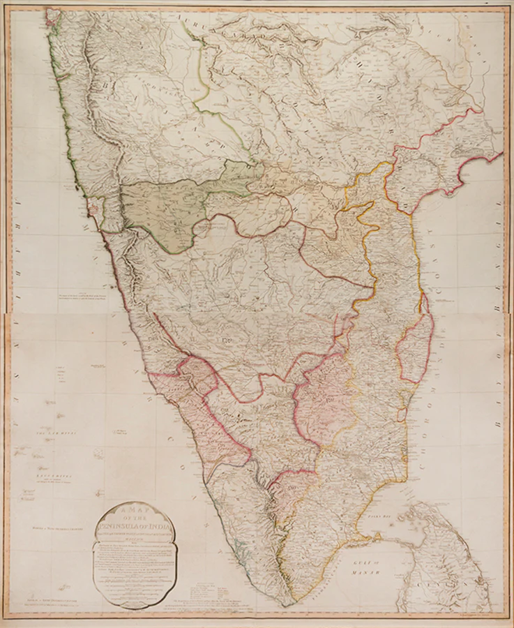
A Map of the Peninsular of India
An interesting sectional map of southern India from the turn of the nineteenth century extending from Bombay in the North, to Cape Comorin in the South, and from Goa in the West to Narsapoor in the East, with hand-colour highlights showing the scope of British control in the region. Compiled from the 'papers communicated by the late Sir Arch[ibald] Campbell, the surveys of Col. Kelly, Capt. Pringle, Capt. Allan &c' (cartouche).
The map was first published in 1792 following the successful conclusion of the Third Anglo-Mysore War and the Treaty of Seringapatam, which ceded over half of Tipu Sultan's lands to Britain and her princely-state allies. This the second edition, shows the outcome of the Fourth and final Anglo-Mysore War, which brought the kingdom's independence to an end in 1799.
William Faden (1749-1836) served as geographer to George III and George IV. 'A gold-medalist of the (Royal) Society of Arts in 1796, he assembled an unrivalled stock of the large-scale maps of the British counties, and became a logical commercial partner for the Ordnance Survey — Faden publishing the first published OS map in 1801. Some of his plates were later acquired by the Admiralty and re-issued as official Admiralty charts. He retired in 1823, the business passing to his former apprentice James Wyld' (BME).
Second edition; engraved map with hand colouring on two conjoined sheets (102 x 82 cm), framed and glazed, overall size: 111 by 93 cm by 2.5cm
$1,005.05
Original: $3,350.17
-70%A Map of the Peninsular of India—
$3,350.17
$1,005.05Product Information
Product Information
Shipping & Returns
Shipping & Returns
Description
An interesting sectional map of southern India from the turn of the nineteenth century extending from Bombay in the North, to Cape Comorin in the South, and from Goa in the West to Narsapoor in the East, with hand-colour highlights showing the scope of British control in the region. Compiled from the 'papers communicated by the late Sir Arch[ibald] Campbell, the surveys of Col. Kelly, Capt. Pringle, Capt. Allan &c' (cartouche).
The map was first published in 1792 following the successful conclusion of the Third Anglo-Mysore War and the Treaty of Seringapatam, which ceded over half of Tipu Sultan's lands to Britain and her princely-state allies. This the second edition, shows the outcome of the Fourth and final Anglo-Mysore War, which brought the kingdom's independence to an end in 1799.
William Faden (1749-1836) served as geographer to George III and George IV. 'A gold-medalist of the (Royal) Society of Arts in 1796, he assembled an unrivalled stock of the large-scale maps of the British counties, and became a logical commercial partner for the Ordnance Survey — Faden publishing the first published OS map in 1801. Some of his plates were later acquired by the Admiralty and re-issued as official Admiralty charts. He retired in 1823, the business passing to his former apprentice James Wyld' (BME).
Second edition; engraved map with hand colouring on two conjoined sheets (102 x 82 cm), framed and glazed, overall size: 111 by 93 cm by 2.5cm
The map was first published in 1792 following the successful conclusion of the Third Anglo-Mysore War and the Treaty of Seringapatam, which ceded over half of Tipu Sultan's lands to Britain and her princely-state allies. This the second edition, shows the outcome of the Fourth and final Anglo-Mysore War, which brought the kingdom's independence to an end in 1799.
William Faden (1749-1836) served as geographer to George III and George IV. 'A gold-medalist of the (Royal) Society of Arts in 1796, he assembled an unrivalled stock of the large-scale maps of the British counties, and became a logical commercial partner for the Ordnance Survey — Faden publishing the first published OS map in 1801. Some of his plates were later acquired by the Admiralty and re-issued as official Admiralty charts. He retired in 1823, the business passing to his former apprentice James Wyld' (BME).
Second edition; engraved map with hand colouring on two conjoined sheets (102 x 82 cm), framed and glazed, overall size: 111 by 93 cm by 2.5cm