🚚 Free Worldwide Shipping on All Orders!Shop Now
1 / 2
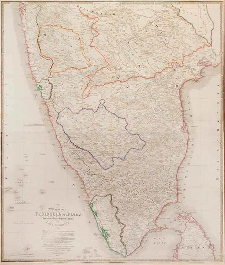
Map of the Peninsula of India,
An interesting sectional map of southern India and northern Ceylon under Company rule, extending from Bombay in the North to Cape Comorin in the South, and from Goa in the West to Narsapoor in the East, with hand-colour highlights showing the scope of British control in the region and the 'Settlements belonging to European Powers'. Compiled 'chiefly from Papers communicated by the late Sir Arch[ibald] Campbell, the surveys of Col. Kelly, Capt. Pringle, Coll. Allan &c' (cartouche).
James Wyld (1812-1887) succeeded to the family business following his father's death in 1836, later serving as geographer to Queen Victoria and Prince Albert. His father had likewise served as Royal Geographer, and had earlier been apprenticed to William Faden, the geographer to George III and George IV. Wyld's peninsula map is based on an earlier design first issued by Faden in 1792.
Engraved map of India (102 x 82 cm), printed on two sheets and expertly joined, with contemporary hand colouring; framed and glazed (151.5 x 112.5 cm).
$783.94
Original: $2,613.13
-70%Map of the Peninsula of India,—
$2,613.13
$783.94Product Information
Product Information
Shipping & Returns
Shipping & Returns
Description
An interesting sectional map of southern India and northern Ceylon under Company rule, extending from Bombay in the North to Cape Comorin in the South, and from Goa in the West to Narsapoor in the East, with hand-colour highlights showing the scope of British control in the region and the 'Settlements belonging to European Powers'. Compiled 'chiefly from Papers communicated by the late Sir Arch[ibald] Campbell, the surveys of Col. Kelly, Capt. Pringle, Coll. Allan &c' (cartouche).
James Wyld (1812-1887) succeeded to the family business following his father's death in 1836, later serving as geographer to Queen Victoria and Prince Albert. His father had likewise served as Royal Geographer, and had earlier been apprenticed to William Faden, the geographer to George III and George IV. Wyld's peninsula map is based on an earlier design first issued by Faden in 1792.
Engraved map of India (102 x 82 cm), printed on two sheets and expertly joined, with contemporary hand colouring; framed and glazed (151.5 x 112.5 cm).
James Wyld (1812-1887) succeeded to the family business following his father's death in 1836, later serving as geographer to Queen Victoria and Prince Albert. His father had likewise served as Royal Geographer, and had earlier been apprenticed to William Faden, the geographer to George III and George IV. Wyld's peninsula map is based on an earlier design first issued by Faden in 1792.
Engraved map of India (102 x 82 cm), printed on two sheets and expertly joined, with contemporary hand colouring; framed and glazed (151.5 x 112.5 cm).