🚚 Free Worldwide Shipping on All Orders!Shop Now
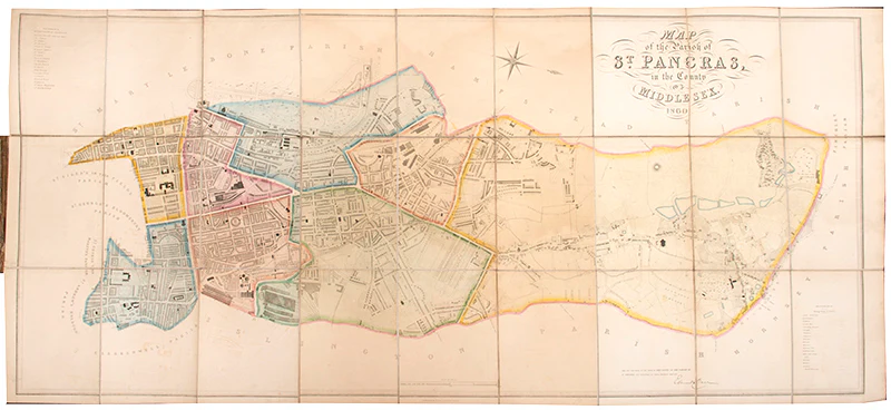
Map of the Parish of St. Pancras in the County of Middlesex.
A large engraved map of St. Pancras orientated to the West extending from Regent's Park to King's Cross in the East, and from Caen Wood (Athlone House) in the North to the Foundling Hospital in the South. With contemporary hand-colouring showing the division of the ancient parish into 8 wards.
Rare. OCLC lists only 2 copies in institutional collections worldwide at the British Library (dated 1849) and University College London (dated 1874).
Engraved map (73 x 160 cm), dissected into 27 parts and laid onto linen as issued, contemporary hand-colouring, folding with marbled endpapers into original brown cloth case; minor offsetting, toned with faint damp staining, slightly frayed along folds, cloth stained, lower spine split, a very good example.
$6,953.61
Map of the Parish of St. Pancras in the County of Middlesex.—
$6,953.61
Product Information
Product Information
Shipping & Returns
Shipping & Returns
Description
A large engraved map of St. Pancras orientated to the West extending from Regent's Park to King's Cross in the East, and from Caen Wood (Athlone House) in the North to the Foundling Hospital in the South. With contemporary hand-colouring showing the division of the ancient parish into 8 wards.
Rare. OCLC lists only 2 copies in institutional collections worldwide at the British Library (dated 1849) and University College London (dated 1874).
Engraved map (73 x 160 cm), dissected into 27 parts and laid onto linen as issued, contemporary hand-colouring, folding with marbled endpapers into original brown cloth case; minor offsetting, toned with faint damp staining, slightly frayed along folds, cloth stained, lower spine split, a very good example.
Rare. OCLC lists only 2 copies in institutional collections worldwide at the British Library (dated 1849) and University College London (dated 1874).
Engraved map (73 x 160 cm), dissected into 27 parts and laid onto linen as issued, contemporary hand-colouring, folding with marbled endpapers into original brown cloth case; minor offsetting, toned with faint damp staining, slightly frayed along folds, cloth stained, lower spine split, a very good example.