🚚 Free Worldwide Shipping on All Orders!Shop Now
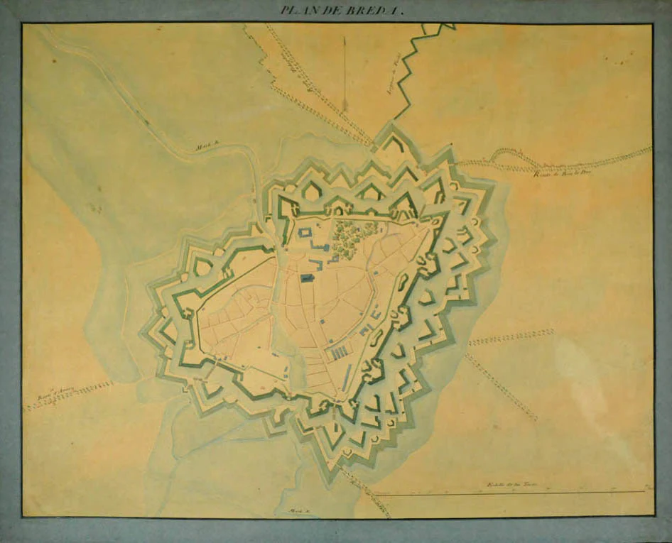
Plan de Breda.
A rare 18th c. manuscript plan of Breda, a fortified city of strategic military and political significance but mostly mapped in the 17th century. Between 1746 and 1748 a series of negotiations between representatives of Great Britain and France, known as The Congress of Breda, took place in that town. They were aimed at bringing an end to the War of the Austrian Succession, and created foundations for the peace settlement at the Treaty of Aix-la-Chapelle.
One-page, manuscript hand-coloured map. Edges strengthened. Slight discolouration to map. Dimensions of the sheet: 63.7 × 80.5 cm (25 × 31.69 inches). Dimensions of the image: 57.3 × 74.5cm (22.55 × 29.33 inches).
One-page, manuscript hand-coloured map. Edges strengthened. Slight discolouration to map. Dimensions of the sheet: 63.7 × 80.5 cm (25 × 31.69 inches). Dimensions of the image: 57.3 × 74.5cm (22.55 × 29.33 inches).
$909,637.48
Plan de Breda.—
$909,637.48
Product Information
Product Information
Shipping & Returns
Shipping & Returns
Description
A rare 18th c. manuscript plan of Breda, a fortified city of strategic military and political significance but mostly mapped in the 17th century. Between 1746 and 1748 a series of negotiations between representatives of Great Britain and France, known as The Congress of Breda, took place in that town. They were aimed at bringing an end to the War of the Austrian Succession, and created foundations for the peace settlement at the Treaty of Aix-la-Chapelle.
One-page, manuscript hand-coloured map. Edges strengthened. Slight discolouration to map. Dimensions of the sheet: 63.7 × 80.5 cm (25 × 31.69 inches). Dimensions of the image: 57.3 × 74.5cm (22.55 × 29.33 inches).
One-page, manuscript hand-coloured map. Edges strengthened. Slight discolouration to map. Dimensions of the sheet: 63.7 × 80.5 cm (25 × 31.69 inches). Dimensions of the image: 57.3 × 74.5cm (22.55 × 29.33 inches).