🚚 Free Worldwide Shipping on All Orders!Shop Now
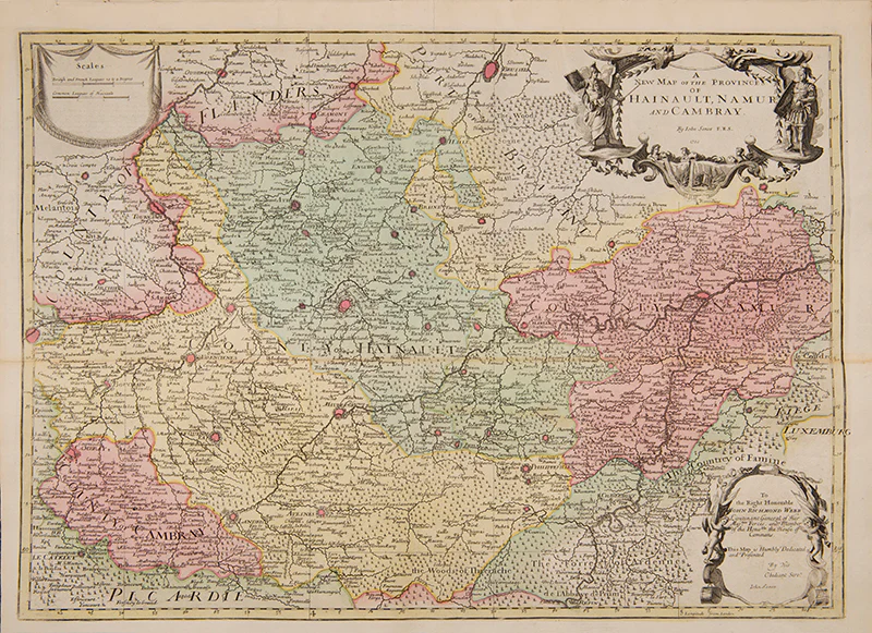
A New Map of the Provinces of Hainault, Namur and Cambray.
John Senex (1678-1740) was one of the foremost mapmakers in England in the early eighteenth century. He was also a surveyor, globemaker, and geographer. As a young man, he was apprenticed to Robert Clavell, a bookseller. He worked with several mapmakers over the course of his career, including Jeremiah Seller and Charles Price. In 1728, Senex was elected as a Fellow of the Royal Society, a rarity for mapmakers. The Fellowship reflects his career-long association as engraver to the Society and publisher of maps by Edmund Halley, among other luminaries. He is best known for his English Atlas (1714), which remained in print until the 1760s. After his death in 1740 his widow, Mary, carried on the business until 1755. Thereafter, his stock was acquired by William Herbert and Robert Sayer (maps) and James Ferguson (globes).10
Engraved map, with full contemporary hand-colouring, size: 470 mm x 640 mm, sheet size: 508 x 685 mm.
Light stain across fold, two splits at fold into margin.
Engraved map, with full contemporary hand-colouring, size: 470 mm x 640 mm, sheet size: 508 x 685 mm.
Light stain across fold, two splits at fold into margin.
$469.02
A New Map of the Provinces of Hainault, Namur and Cambray.—
$469.02
Product Information
Product Information
Shipping & Returns
Shipping & Returns
Description
John Senex (1678-1740) was one of the foremost mapmakers in England in the early eighteenth century. He was also a surveyor, globemaker, and geographer. As a young man, he was apprenticed to Robert Clavell, a bookseller. He worked with several mapmakers over the course of his career, including Jeremiah Seller and Charles Price. In 1728, Senex was elected as a Fellow of the Royal Society, a rarity for mapmakers. The Fellowship reflects his career-long association as engraver to the Society and publisher of maps by Edmund Halley, among other luminaries. He is best known for his English Atlas (1714), which remained in print until the 1760s. After his death in 1740 his widow, Mary, carried on the business until 1755. Thereafter, his stock was acquired by William Herbert and Robert Sayer (maps) and James Ferguson (globes).10
Engraved map, with full contemporary hand-colouring, size: 470 mm x 640 mm, sheet size: 508 x 685 mm.
Light stain across fold, two splits at fold into margin.
Engraved map, with full contemporary hand-colouring, size: 470 mm x 640 mm, sheet size: 508 x 685 mm.
Light stain across fold, two splits at fold into margin.