🚚 Free Worldwide Shipping on All Orders!Shop Now
1 / 5
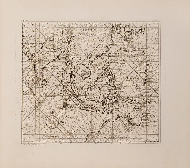
Allerneuester Geographisch- und Topographischer
important early iconography of Jakarta
Heydt's Ost-Indien provides us with an extensive and important work with regard to the town planning and general topography of Jakarta in the first half of the eighteenth century. Heydt describes the main factories, settlements and stations of the Netherlands East India Company (VOC) in Africa and Asia, at Jakarta [Batavia], Colombo, Malacca, the Molluccas, Japan, and the Cape. The maps include a twin-hemisphere World map, the East Indies [with northern Australia], Sri Lanka and Greenland. The views include scenes and interiors at Jakarta, Colombo, Malacca and the settlement at Deshima in Japan.Heydt, born in Amboina in 1702 to German parents, joined the VOC in 1733, spending two years in Ceylon before going to Indonesia. In 1737 he became the architect and draughtsman of the Company. In this capacity he made numerous drawings of Jakarta and West Java. He retired to Europe after resigning from the VOC in 1740 on health grounds.
First edition; landscape folio (33 x 39 cm); 115 engraved plates (plate 62, plan of Colombo, hand-coloured) including five maps, by J.M. Seeligman, A. Hoffer, J.G. Puscher, and J.C. Berndt after Heydt, bound without the frontispiece found in some copies, a little browned as usual, more so at beginning and end; contemporary vellum, morocco label, covers a bit marked, overall a very good copy; [20], 346, [4] pp.
Landwehr (VOC), 469; Mendelssohn (South African Bibliography) I, 709.
$3,554.24
Original: $11,847.47
-70%Allerneuester Geographisch- und Topographischer—
$11,847.47
$3,554.24Product Information
Product Information
Shipping & Returns
Shipping & Returns
Description
important early iconography of Jakarta
Heydt's Ost-Indien provides us with an extensive and important work with regard to the town planning and general topography of Jakarta in the first half of the eighteenth century. Heydt describes the main factories, settlements and stations of the Netherlands East India Company (VOC) in Africa and Asia, at Jakarta [Batavia], Colombo, Malacca, the Molluccas, Japan, and the Cape. The maps include a twin-hemisphere World map, the East Indies [with northern Australia], Sri Lanka and Greenland. The views include scenes and interiors at Jakarta, Colombo, Malacca and the settlement at Deshima in Japan.Heydt, born in Amboina in 1702 to German parents, joined the VOC in 1733, spending two years in Ceylon before going to Indonesia. In 1737 he became the architect and draughtsman of the Company. In this capacity he made numerous drawings of Jakarta and West Java. He retired to Europe after resigning from the VOC in 1740 on health grounds.
First edition; landscape folio (33 x 39 cm); 115 engraved plates (plate 62, plan of Colombo, hand-coloured) including five maps, by J.M. Seeligman, A. Hoffer, J.G. Puscher, and J.C. Berndt after Heydt, bound without the frontispiece found in some copies, a little browned as usual, more so at beginning and end; contemporary vellum, morocco label, covers a bit marked, overall a very good copy; [20], 346, [4] pp.
Landwehr (VOC), 469; Mendelssohn (South African Bibliography) I, 709.