🚚 Free Worldwide Shipping on All Orders!Shop Now
1 / 3
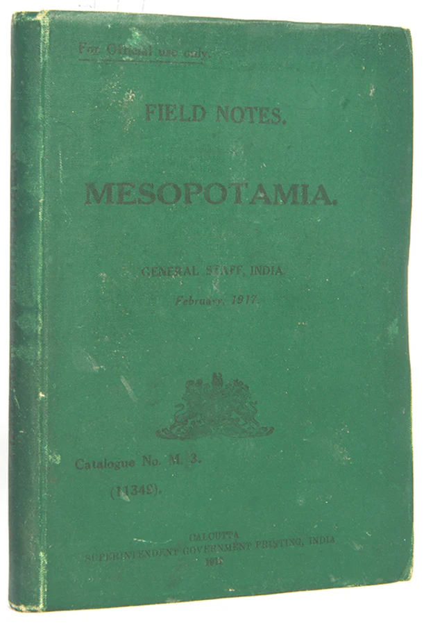
Field Notes. Mesopotamia.
for official use only
The second, enlarged edition of this scarce intelligence guide produced for the British Indian Army operating in Mesopotamia (Iraq) and the Arabian peninsular during the First World War, with the improved colour-printed lithograph map extending from Samarra in the North, to Hafar al-Batin in the South, and from the Wadi al-Khair in the West to Kuwait in the East.Designed for official use only, the map and guide put particular emphasis on routes and rivers, but also provides an interesting overview of the region's history and an assessment of its current political climate. Qatar and Kuwait, which 'now flies a flag of its own' in the region, both receive early mentions (p.4).
A glossary located to the rear provides helpful definitions of local words, like 'Ghazi... A champion of Islam', and 'Qalib... A well with a wide mouth, and very broad near the water. Men often descend into it to fill their water-skins'. Interestingly, Arab is translated as 'A man of one of the Arab tribes, but not necessarily a Bedouin. The plural Aarab* denotes the people, the nation. When applied to a Shaikh, as "Zaid's Aarab," it means followers'.
Second, enlarged edition; 8vo (18 x 13 cm); folding lithographic map of Lower Mesopotamia in pocket, 3 folding tables, without the separately printed index; original green cloth wallet binding, spine and upper panel lettered in black, little wear to extremities, a very good copy; [4], 326, [1]pp.
$1,407.07
Original: $4,690.23
-70%Field Notes. Mesopotamia.—
$4,690.23
$1,407.07Product Information
Product Information
Shipping & Returns
Shipping & Returns
Description
for official use only
The second, enlarged edition of this scarce intelligence guide produced for the British Indian Army operating in Mesopotamia (Iraq) and the Arabian peninsular during the First World War, with the improved colour-printed lithograph map extending from Samarra in the North, to Hafar al-Batin in the South, and from the Wadi al-Khair in the West to Kuwait in the East.Designed for official use only, the map and guide put particular emphasis on routes and rivers, but also provides an interesting overview of the region's history and an assessment of its current political climate. Qatar and Kuwait, which 'now flies a flag of its own' in the region, both receive early mentions (p.4).
A glossary located to the rear provides helpful definitions of local words, like 'Ghazi... A champion of Islam', and 'Qalib... A well with a wide mouth, and very broad near the water. Men often descend into it to fill their water-skins'. Interestingly, Arab is translated as 'A man of one of the Arab tribes, but not necessarily a Bedouin. The plural Aarab* denotes the people, the nation. When applied to a Shaikh, as "Zaid's Aarab," it means followers'.
Second, enlarged edition; 8vo (18 x 13 cm); folding lithographic map of Lower Mesopotamia in pocket, 3 folding tables, without the separately printed index; original green cloth wallet binding, spine and upper panel lettered in black, little wear to extremities, a very good copy; [4], 326, [1]pp.