🚚 Free Worldwide Shipping on All Orders!Shop Now
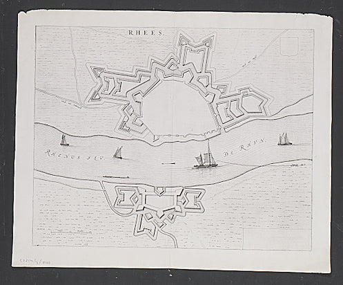
Rhees.
The Netherlands
Plan of fortifications at Rees from Joan Blaeu's town book of the Netherlands, first published one year after the peace of Munster and the Spanish acknowledgement of the Dutch Republic. Blaeu planned his town book towards the end of the battle with Spain to consist of two volumes; one showing the towns of the Republic, the other showing towns belonging to Spain. In the second edition, due to a large scale re-conquest of land by the Republic, Blaeu had to transfer several towns to the volume showing towns of the Republic and as a consequence this volume became larger than the other; thus the composition of the atlas became linked to the struggle for independence of the Republic. A schematic depiction of a fortification such as this one reflects this struggle.Double-page engraved map, Latin text on verso; Dimensions: 420 x 530mm.(16.5 x 21 inches).
Koeman, Atlantes Neerlandici B1 64.
$40.20
Original: $134.01
-70%Rhees.—
$134.01
$40.20Product Information
Product Information
Shipping & Returns
Shipping & Returns
Description
The Netherlands
Plan of fortifications at Rees from Joan Blaeu's town book of the Netherlands, first published one year after the peace of Munster and the Spanish acknowledgement of the Dutch Republic. Blaeu planned his town book towards the end of the battle with Spain to consist of two volumes; one showing the towns of the Republic, the other showing towns belonging to Spain. In the second edition, due to a large scale re-conquest of land by the Republic, Blaeu had to transfer several towns to the volume showing towns of the Republic and as a consequence this volume became larger than the other; thus the composition of the atlas became linked to the struggle for independence of the Republic. A schematic depiction of a fortification such as this one reflects this struggle.Double-page engraved map, Latin text on verso; Dimensions: 420 x 530mm.(16.5 x 21 inches).
Koeman, Atlantes Neerlandici B1 64.