🚚 Free Worldwide Shipping on All Orders!Shop Now
A New and Correct Map of the World
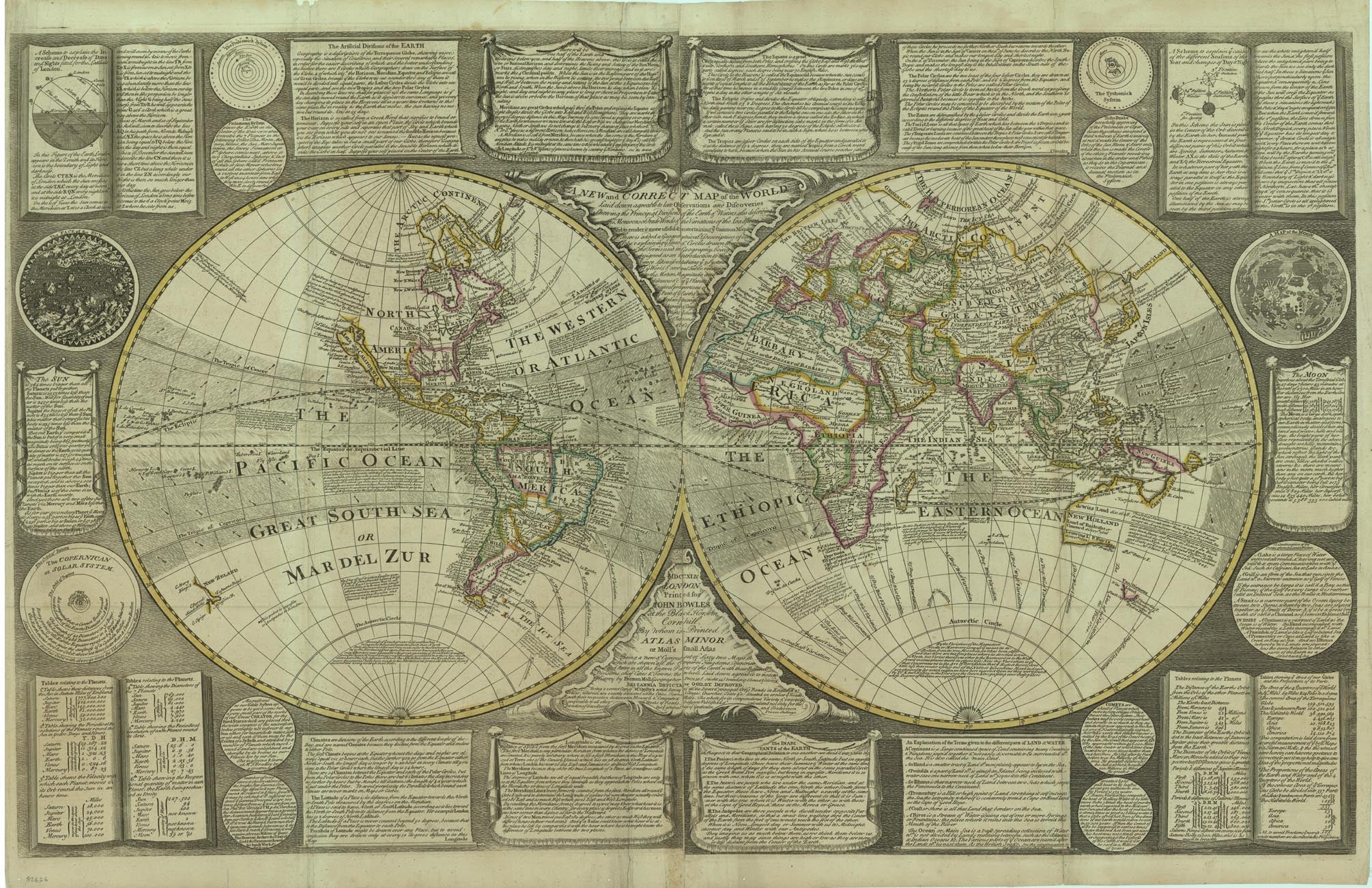
A fine summary of English cartographic knowledge at the edge of the mid-18th century: one of the largest and most important maps that Bowles produced, and among the rarest. The only other example located is in the British Library.
John Bowles, member of the leading family of printsellers, is best known as a publisher of prints and, with his brother, Thomas (II) as an acquirer and re-user of old printing plates, but he also had a relatively small output of "new" maps which are among the most interesting and important productions of the period; most of these were sold separately, which accounts for their rarity today.
In the eighteenth century, British map publishers developed an important sequence of two-sheet double hemisphere world maps for sale to their customers, marketed as containing the latest scientific data, notably by inserting detailed panels of texts or technical insets, appealing to the cultural and social pretensions of the buyers who would display these maps in their houses or offices and bask in the reflected credit of having the most up-to-date maps in their possession.
One of the finest, and among the rarest, maps in this sequence was published by John Bowles in 1744. The borders around the map are literally crammed with insets and lengthy explanatory texts, which combine to make the map a pictorial and textual encyclopaedia of contemporary geographical knowledge and among the most striking map images of the day.
He advertised it as 'A New map of the World, laid down agreeable to late observations and discoveries, shewing the principal divisions of the earth and waters, also describing the monsoon or trade-winds, and the variation of the loadstone. To render this map more useful and entertaining, it contains a geographical description of the terrestrial globe, explaining the lines and circles which geographers drawn thereon, and the terms used in geography. Also the three systems of the World, and several tables shewing the motions, magnitudes, and distances, &c. of the planets; the proportions of the several parts of the earth, and schemes to explain the increase and decrease of day and night, the changes of the seasons, &c. &c.' As such, this large map depicts the world as known on the eve of the Seven Years' War, which established Britain as the pre-eminent colonial power, and on the eve of the great period of British marine exploration in the last decades of the eighteenth century, which transformed European knowledge of the wider world.
Typical of the family is the way Bowles' imprint also serves as a brief catalogue of related items from stock.
Large engraved map on two sheets joined, original hand-colour in outline, advertisements, diagrams and explanations to borders. Dimensions: 61 x 97 cm (24 by 38.25 inches).
BLMC Maps Maps * 920.(366.); Armitage & Baynton-Williams: World at their Fingertips, 18.1 (this example illustrated); Worms & Baynton-Williams: British Map Engravers: Bowles, John.
$2,122,532.12
A New and Correct Map of the World—
$2,122,532.12
Product Information
Product Information
Shipping & Returns
Shipping & Returns
Description
A fine summary of English cartographic knowledge at the edge of the mid-18th century: one of the largest and most important maps that Bowles produced, and among the rarest. The only other example located is in the British Library.
John Bowles, member of the leading family of printsellers, is best known as a publisher of prints and, with his brother, Thomas (II) as an acquirer and re-user of old printing plates, but he also had a relatively small output of "new" maps which are among the most interesting and important productions of the period; most of these were sold separately, which accounts for their rarity today.
In the eighteenth century, British map publishers developed an important sequence of two-sheet double hemisphere world maps for sale to their customers, marketed as containing the latest scientific data, notably by inserting detailed panels of texts or technical insets, appealing to the cultural and social pretensions of the buyers who would display these maps in their houses or offices and bask in the reflected credit of having the most up-to-date maps in their possession.
One of the finest, and among the rarest, maps in this sequence was published by John Bowles in 1744. The borders around the map are literally crammed with insets and lengthy explanatory texts, which combine to make the map a pictorial and textual encyclopaedia of contemporary geographical knowledge and among the most striking map images of the day.
He advertised it as 'A New map of the World, laid down agreeable to late observations and discoveries, shewing the principal divisions of the earth and waters, also describing the monsoon or trade-winds, and the variation of the loadstone. To render this map more useful and entertaining, it contains a geographical description of the terrestrial globe, explaining the lines and circles which geographers drawn thereon, and the terms used in geography. Also the three systems of the World, and several tables shewing the motions, magnitudes, and distances, &c. of the planets; the proportions of the several parts of the earth, and schemes to explain the increase and decrease of day and night, the changes of the seasons, &c. &c.' As such, this large map depicts the world as known on the eve of the Seven Years' War, which established Britain as the pre-eminent colonial power, and on the eve of the great period of British marine exploration in the last decades of the eighteenth century, which transformed European knowledge of the wider world.
Typical of the family is the way Bowles' imprint also serves as a brief catalogue of related items from stock.
Large engraved map on two sheets joined, original hand-colour in outline, advertisements, diagrams and explanations to borders. Dimensions: 61 x 97 cm (24 by 38.25 inches).
BLMC Maps Maps * 920.(366.); Armitage & Baynton-Williams: World at their Fingertips, 18.1 (this example illustrated); Worms & Baynton-Williams: British Map Engravers: Bowles, John.
John Bowles, member of the leading family of printsellers, is best known as a publisher of prints and, with his brother, Thomas (II) as an acquirer and re-user of old printing plates, but he also had a relatively small output of "new" maps which are among the most interesting and important productions of the period; most of these were sold separately, which accounts for their rarity today.
In the eighteenth century, British map publishers developed an important sequence of two-sheet double hemisphere world maps for sale to their customers, marketed as containing the latest scientific data, notably by inserting detailed panels of texts or technical insets, appealing to the cultural and social pretensions of the buyers who would display these maps in their houses or offices and bask in the reflected credit of having the most up-to-date maps in their possession.
One of the finest, and among the rarest, maps in this sequence was published by John Bowles in 1744. The borders around the map are literally crammed with insets and lengthy explanatory texts, which combine to make the map a pictorial and textual encyclopaedia of contemporary geographical knowledge and among the most striking map images of the day.
He advertised it as 'A New map of the World, laid down agreeable to late observations and discoveries, shewing the principal divisions of the earth and waters, also describing the monsoon or trade-winds, and the variation of the loadstone. To render this map more useful and entertaining, it contains a geographical description of the terrestrial globe, explaining the lines and circles which geographers drawn thereon, and the terms used in geography. Also the three systems of the World, and several tables shewing the motions, magnitudes, and distances, &c. of the planets; the proportions of the several parts of the earth, and schemes to explain the increase and decrease of day and night, the changes of the seasons, &c. &c.' As such, this large map depicts the world as known on the eve of the Seven Years' War, which established Britain as the pre-eminent colonial power, and on the eve of the great period of British marine exploration in the last decades of the eighteenth century, which transformed European knowledge of the wider world.
Typical of the family is the way Bowles' imprint also serves as a brief catalogue of related items from stock.
Large engraved map on two sheets joined, original hand-colour in outline, advertisements, diagrams and explanations to borders. Dimensions: 61 x 97 cm (24 by 38.25 inches).
BLMC Maps Maps * 920.(366.); Armitage & Baynton-Williams: World at their Fingertips, 18.1 (this example illustrated); Worms & Baynton-Williams: British Map Engravers: Bowles, John.